
TL;DR
A large winter storm is spreading ice and heavy snow from the Great Lakes to the Northeast, snarling air travel and bringing New York City its biggest snowfall in nearly four years.
Why This Matters
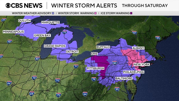
A wide swath of the country from the Upper Midwest to the Northeast is under winter weather alerts as a powerful storm moves through, affecting tens of millions of people. Ice, sleet and freezing rain can be more dangerous than snow alone, making roads slick, increasing the risk of crashes and raising the chance of power outages if ice accumulates on trees and power lines.
The timing of this system, stretching from Friday into Saturday, hits a busy travel period, with already more than 1,300 flights canceled and thousands delayed across the United States, according to flight-tracking service FlightAware. That means potential disruptions not just for those in the direct path of the storm, but also for passengers connecting through major hubs.
For the New York City region, this is not just another winter event. Forecasts call for the city’s heaviest snowfall in nearly four years, a sharp change after several winters with little accumulation. Communities from Michigan to Pennsylvania and northward into New York and New Jersey also face significant impacts on daily routines, commuting, and outdoor work.
Key Facts & Quotes
The storm arrived Friday across the Great Lakes and Northeast and is expected to linger into Saturday. Ice, sleet and freezing rain are forecast from the Upper Midwest through the Mid-Atlantic, while heavier snow targets parts of New York state, including the New York City metro area.
Key Messages on the big northeast winter storm. Snow and ice impacts expected this next day. https://t.co/Hk3pbO84Yf pic.twitter.com/dDdxtqBo6b
— Mike’s Weather Page (@tropicalupdate) December 26, 2025
More than 1,300 U.S. flights were canceled Friday, with thousands more delayed, according to FlightAware. Millions of Americans are under some form of winter weather advisory or warning, with the most serious alerts in parts of central Pennsylvania, the New York Tri-State region and areas to the north.
An ice storm warning is in effect through Saturday morning for several central Pennsylvania counties, including Somerset, Indiana, Clarion and Venango. Ice is the main concern from central Michigan through southwestern New York and into central Pennsylvania, where forecasters warn that freezing rain and sleet could make roads extremely treacherous.
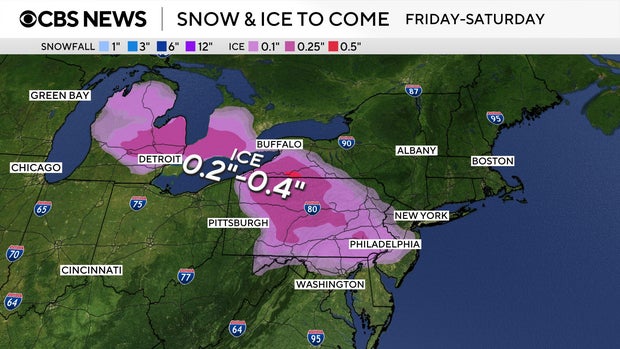
In the Pittsburgh area, local forecasts suggest a brief period of freezing rain before a changeover to rain, but parts of central Pennsylvania could see ice accumulation of a quarter-inch or more. The New York City area, by contrast, is bracing for a major snow event from Friday afternoon into Saturday.
Forecasters in New York say 4 to 8 inches of snow are likely across the metro area, with northern communities possibly reaching 10 inches, and even higher totals in the Catskills and Pocono Mountains. Central and coastal New Jersey, including the Jersey Shore, are expected to see 3 to 5 inches of snow because of mixing with sleet and freezing rain.

“Get ready for moderate to heavy snow that could accumulate pretty quickly – inch or two an hour snowfall rates will mean treacherous conditions on the road, poor visibility, slick conditions right through the overnight hours,” CBS News New York meteorologist Tony Sadiku said. “This will be a lot to shovel, so pace yourself.”
If forecasts hold, this would be New York City’s biggest snowfall since Jan. 28-29, 2022, when a coastal storm dropped 8.5 inches in Central Park.
What It Means for You
For residents from Michigan to Maine, the latest update means planning around hazardous travel, especially from Friday evening into Saturday morning when conditions are expected to be worst. If you must drive, officials typically advise slowing down, allowing extra distance between vehicles and being prepared for sudden changes in visibility and road surface.
Air travelers should check flight status frequently and consider backup plans in case of cancellations or missed connections. Those in areas expecting heavy, wet snow or ice may want to charge devices, gather flashlights and ensure they have basic supplies in case of brief power outages.
For older adults, people with heart or lung conditions and anyone planning to shovel, health experts often recommend taking breaks, lifting smaller loads of snow, and avoiding overexertion. As the storm moves out, watch for refreezing overnight and updated advisories from local weather offices before resuming normal routines.
How are you adjusting your weekend plans in light of the forecast for ice and heavy snow?